Death toll in Indonesian floods, volcanic mud flows rises to 41 | Volcanoes News

At least 17 people still missing after heavy rains washed mud and cold lava down the slopes of Mount Marapi.

At least 41 people have now been confirmed dead after hours of torrential rain triggered flash floods and cold lava flow from a volcano in western Indonesia over the weekend.

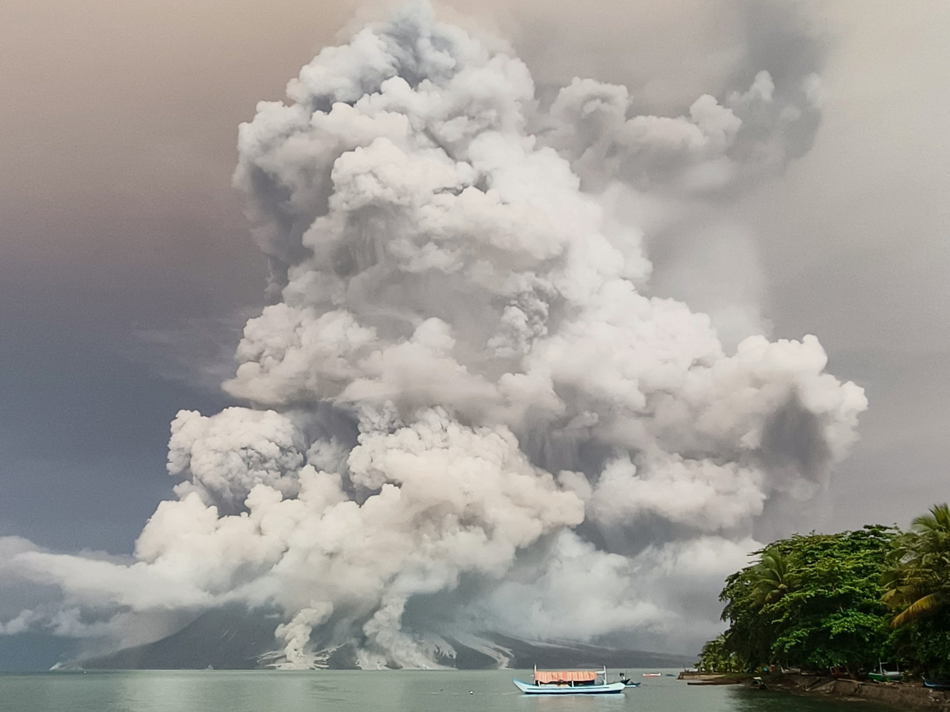
A local disaster official told the AFP news agency that 17 other people remained missing after the downpour on Saturday night swept ash and large rocks down Mount Marapi, the most active volcano on Sumatra island.

Three people are missing in the Agam district and 14 in Tanah Datar, both the worst-hit areas of the flood and home to hundreds of thousands of people, Ilham Wahab, an official with the West Sumatra disaster mitigation agency, told AFP.

About 400 people, including police, soldiers and local rescue squads, have been deployed to search for the missing, using at least eight excavators and drones.

Marapi erupted in December, killing more than 20 people.

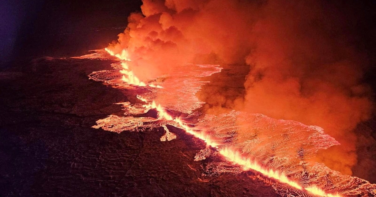
Cold lava, also known as lahar, is volcanic material such as ash, sand and pebbles carried down a volcano’s slopes by rain.

The rain turned roads into muddy rivers, swept vehicles away and damaged homes and other buildings.

Damage to the roads has hampered rescue efforts.

Indonesia is prone to landslides and floods during the rainy season.

In 2022, about 24,000 people were evacuated and two children were killed in floods on Sumatra island, with environmental campaigners blaming deforestation caused by logging for worsening the disaster.

Residents clamber over debris after Saturday night’s flash floods [Iggo El Fitra/Antara Foto via Reuters]

Check out our Latest News and Follow us at Facebook

Original Source

Thousands evacuated, flights disrupted as Indonesian volcano erupts again | Volcanoes News

Mount Ruang in the central province of North Sulawesi sent thick clouds of ash more than 5km (3 miles) into the sky.

Thousands of people have been evacuated and flights disrupted after Indonesia’s Mount Ruang erupted again, sending thick clouds of ash more than 5km (3 miles) into the sky.

Officials said the volcano in the archipelago’s North Sulawesi province erupted at least three times on Tuesday, prompting fears debris might fall into the sea and cause a tsunami.

Footage shared by Indonesia’s disaster mitigation agency (BNPB) showed strikes of lightning flashing above Ruang’s crater as fiery red clouds of lava and rocks were thrown into the air.

The agency said that all 843 residents living on Ruang Island, where the volcano is located, had been moved to Manado, the provincial capital about 100km (62 miles) away. Some 12,000 people from the neighbouring Tagulandang Island are being evacuated to Siau Island further north with two ships deployed to help with the process.

Rosalin Salindeho, a 95-year-old Tagulandang resident, spoke of her fears when Ruang erupted after arriving in Siau.

“The mountain exploded. Wow, it was horrible. There were rains of rocks. Twice. The second one was really heavy, even the houses far away were also hit,” she said.

Indonesia’s meteorological agency (BMKG) shared a map on Wednesday morning that showed volcanic ash had reached as far as Borneo, the island Indonesia shares with Brunei and Malaysia.

Indonesian air traffic control agency AirNav Indonesia said seven airports had been forced to close including in Manado and the city of Gorontalo.

Malaysia Airlines said the ash led to the cancellation of some flights to and from airports in the Borneo states of Sabah and Sarawak, with travel dependent on the weather conditions. North Sulawesi is in the central part of the Indonesian archipelago.

Julius Ramopolii, the head of the Mount Ruang monitoring post, said the volcano was still billowing ash and smoke above the crater on Wednesday morning.

“The volcano is visibly seen, the plume of smoke is visible, grey and thick, and reached 500-700 metres (2,300 feet) above the crater,” he said in a statement.

He said the alert level remained at its highest of a four-tiered system and called on residents to remain outside a seven-kilometre exclusion zone declared by the authorities.

Indonesia sees regular earthquakes and volcanic eruptions as a result of its position on the Pacific “Ring of Fire” where multiple tectonic plates meet.

Mount Ruang recorded a series of eruptions earlier in April that also led to evacuations and disruption to aviation amid fears of a tsunami.

In 2018, the crater of Mount Anak Krakatoa, between Java and Sumatra islands, partly collapsed during a major eruption that sent huge chunks of the volcano sliding into the ocean, leading to a tsunami that killed more than 400 people and injured thousands more.

Check out our Latest News and Follow us at Facebook

Original Source

Indonesia’s Mount Ruang volcano erupts during lightning storm | Volcanoes

NewsFeed

Video shows a spectacular lightning storm during an eruption on Indonesia’s Mount Ruang volcano. Hundreds of people have been evacuated from the area.

Check out our Latest News and Follow us at Facebook

Original Source

11,000 evacuated in northern Indonesia as Ruang volcano erupts | Volcanoes News

Authorities further extend exclusion zone after volcano sends ash and smoke more than two kilometres into the sky.

Some 11,000 people have been evacuated from around the Ruang volcano in northern Indonesia amid fears it could collapse causing a tsunami after erupting multiple times.

Mount Ruang, located in in North Sulawesi Province, first erupted at 9:45pm (13:45 GMT) on Tuesday sending billowing clouds of smoke and ash high into the sky.

After four more eruptions on Wednesday, Indonesia’s volcanology agency raised the alert level for the 725-metre (2,379-foot) high mountain to four, the highest on the scale.

They also widened the exclusion zone around the crater from four kilometres (2.5 miles) to six kilometres (3.7 miles).

More than 800 people were evacuated initially from Ruang to nearby Tagulandang Island, which is located more than 100 kilometres (62 miles) north of the provincial capital, Manado.

But officials said later that everyone on Tagulandang would also need to be evacuated as a result of the widening exclusion zone, and would be taken to Manado.

Officials also worry that part of the volcano could collapse into the sea and cause a tsunami as it did during a previous eruption in 1871.

Video footage showed flows of red lava streaming down the mountain, reflected in the waters below, and billowing clouds of grey ash above Ruang’s crater.

Muhammad Wafid, the head of Indonesia’s geological agency, earlier said Ruang’s initial eruption sent an ash column two kilometres (1.2 miles) into the sky, with the second eruption pushing it to 2.5 kilometres (1.6 miles).

The volcanology agency said volcanic activity had increased at Ruang after two earthquakes in recent weeks.

Indonesia, which sits along the ‘Ring of Fire’, a horseshoe-shaped series of tectonic fault lines around the Pacific Ocean, has 120 active volcanoes.

In 2018, the eruption of Indonesia’s Anak Krakatoa volcano triggered a tsunami along the coasts of Sumatra and Java after parts of the mountain fell into the ocean. Hundreds of people were killed.

Check out our Latest News and Follow us at Facebook

Original Source

Rare phenomenon in skies over Italy’s Mount Etna | Volcanoes

NewsFeed

The skies above Mount Etna are sprinkled with perfectly shaped rings of smoke coming from Europe’s most active volcano. The rare phenomenon of ‘volcanic vortex rings’ occurs during the rapid release of gas through a vent-shaped crater that opened on Etna’s summit earlier this month.

Check out our Latest News and Follow us at Facebook

Original Source

Iceland in state of emergency after volcano erupts, fourth time in 3 months | Volcanoes

Icelandic police declared a state of emergency on Saturday as lava spewed from a new volcanic fissure on the Reykjanes Peninsula, the fourth eruption to hit the area since December.

A “volcanic eruption has started between Stori-Skogfell and Hagafell on the Reykjanes Peninsula,” said a statement from the Icelandic Meteorological Office (IMO). Live video images showed glowing lava and billowing smoke.

Iceland’s Department of Civil Protection and Emergency Management announced it had sent a helicopter to narrow down the exact location of the new fissure. The authority also said the police had declared a state of emergency due to the eruption.

According to the IMO, it occurred close to the same location as a previous eruption on February 8. Lava appeared to flow south towards the dykes built to protect the fishing village Grindavik, it said.

Just after 22:00 GMT, “the southern lava front was just 200 metres [656 feet] from the barriers on the eastern side of Grindavik and moving at a rate of about one km per hour”, it added.

Hundreds of people were evacuated from the Blue Lagoon thermal spa, one of Iceland’s top tourist attractions, when the eruption began, national broadcaster RUV said.

No flight disruptions were reported at nearby Keflavik, Iceland’s main airport.

The eruption site is a few kilometres northeast of Grindavik, a coastal town of 3,800 people about 50km (30 miles) southwest of Iceland’s capital, Reykjavik, that was evacuated before the initial eruption in December. A few residents who had returned to their homes were evacuated again on Saturday.

Grindavik was evacuated in November when the Svartsengi volcanic system awakened after almost 800 years with a series of earthquakes that opened large cracks in the ground north of the town.

The volcano eventually erupted on December 18, sending lava flowing away from Grindavik. A second eruption that began on January 14 sent lava towards the town. Defensive walls that had been bolstered after the first eruption stopped some of the flow, but several buildings were consumed by the lava.

Both eruptions lasted only a matter of days. A third eruption began February 8. It petered out within hours, but not before a river of lava engulfed a pipeline, cutting off heat and hot water to thousands of people.

RUV quoted geophysicist Magnus Tumi Gudmundsson as saying that the latest eruption is the most powerful so far. The IMO said some of the lava was flowing towards the defensive barriers around Grindavik.

Iceland, which sits above a volcanic hot spot in the North Atlantic, sees regular eruptions and is highly experienced at dealing with them. The most disruptive in recent times was the 2010 eruption of the Eyjafjallajokull volcano, which spewed huge clouds of ash into the atmosphere and led to widespread airspace closures over Europe.

No confirmed deaths have been reported from any of the recent eruptions, but a workman was declared missing after falling into a fissure opened by the volcano.

Check out our Latest News and Follow us at Facebook

Original Source

Photos: Lava destroys homes in Iceland’s Grindavik | Volcanoes News

Iceland’s president said the country is battling “tremendous forces of nature” after molten lava from a volcano in the island’s southwest consumed several houses in the evacuated town of Grindavik.

President Gudni Thorlacius Johannesson said in a televised address late on Sunday that “a daunting period of upheaval has begun on the Reykjanes Peninsula”, where a long-dormant volcanic system has awakened.

A volcano on the peninsula erupted for the second time in less than a month on Sunday morning. Authorities had ordered residents to leave the fishing town of Grindavik hours earlier as a swarm of small earthquakes indicated an imminent eruption.

Geophysicist Magnus Tumi Gudmundsson said on Monday morning that the eruption had “decreased considerably” overnight, but that it was impossible to say when it would end.

Grindavik, a town of 3,800 people about 50km (30 miles) southwest of the capital, Reykjavik, was previously evacuated in November when the Svartsengi volcanic system awakened after almost 800 years.

Since then, emergency workers have been building defensive walls that have stopped much of the lava flow from the new eruption short of the town.

There have been no confirmed deaths as a result of the eruptions, but a workman is missing after reportedly falling into a crack opened by the volcano.

Iceland, which sits above a volcanic hot spot in the North Atlantic, averages one eruption every four to five years. The most disruptive in recent times was the 2010 eruption of the Eyjafjallajokull volcano, which spewed clouds of ash into the atmosphere and disrupted transatlantic air travel for months.

The latest eruption isn’t expected to release large amounts of ash into the air. Operations at Keflavik Airport are continuing as normal, said Gudjon Helgason, spokesman for airport operator Isavia.

Check out our Latest News and Follow us at Facebook

Original Source

Natural disasters that plagued the world in 2023 | Climate Crisis

Natural calamities and harsh weather dominated news headlines in 2023.

Seismic tremors, massive floods, raging wildfires, unrelenting droughts, landslides, cyclones and storms hit around the world, killing and displacing tens of thousands of people.

The most destructive event of the year was a twin earthquake with magnitudes of 7.8 and 7.5 that struck southern Turkey near the Syrian border on February 6. An estimated 14 million people, representing 16 percent of Turkey’s population, were affected. Confirmed deaths totalled 50,783 in Turkey and 8,476 in Syria.

On September 8, a magnitude 6.8 earthquake struck western Morocco, killing at least 2,900 people and wounding 5,500.  A magnitude 6.3 earthquake rocked western Afghanistan on October 7. It was followed by another magnitude 6.3 earthquake four days later and a magnitude 6.4 earthquake on October 15, killing almost 3,000.

Typhoon Doksuri caused significant rainfall and flooding throughout at least 16 cities and provinces in northeastern China on July 29. In September, Mediterranean Storm Daniel passed across eastern Libya, leaving a path of devastation.

In September, October and November, storms also caused flooding in Mexico, Hong Kong and Western Europe.

The Horn of Africa – only slowly emerging from a devastating drought that left millions hungry – also experienced heavy rainfall and floods linked to the El Nino weather phenomenon. The flash floods in November killed dozens of people and caused large-scale displacement in Kenya, as well as Somalia and Ethiopia.

On the other hand, record droughts caused river levels to fall and other water bodies to dry up across various parts of the world, including the Amazon rainforest.

Scientists say these kinds of extreme weather events will become more common and more severe as the earth warms.

Here are some images that show some of the major disasters of 2023 around the world and their effects on people, animals and the natural landscape.

Check out our Latest News and Follow us at Facebook

Original Source

Aerial video shows volcano erupting in Iceland | Volcanoes News

NewsFeed

A volcano in Iceland has started erupting after weeks of earthquake activity that forced the evacuation of a nearby town as a precaution.

Check out our Latest News and Follow us at Facebook

Original Source

Iceland volcano erupts, spewing lava, smoke after weeks of earthquakes | Volcanoes News

A volcano in southwest Iceland has erupted, spewing lava and smoke across a wide area weeks after nearly 4,000 residents of a nearby town were evacuated amid intense seismic activity.

The eruption started at about 10:17pm (22:17 GMT) on Monday on Iceland’s Reykjanes peninsula, turning the sky orange and prompting the country’s civil defence to be on high alert. It appeared to have taken place about 4km (2.4 miles) from the town of Grindavik, the Icelandic Meteorological Office said.

Livestreamed footage of the eruption showed glowing orange jets of lava spewing from a gash in the ground, surrounded by billowing clouds of red smoke.

Iceland has been on high alert for a potential eruption after thousands of small earthquakes rattled the region about 40km (25 miles) south of the capital, Reykjavik, prompting the evacuation in November of the fishing town of Grindavik and the closure of the nearby Blue Lagoon geothermal spa.

Iceland sits above a volcanic hot spot in the North Atlantic and averages an eruption every four to five years. The most disruptive in recent times was the 2010 eruption of the Eyjafjallajokull volcano, which spewed huge clouds of ash into the atmosphere and grounded flights across Europe for days because of fears that the ash could damage aeroplane engines.

Scientists say a new eruption would likely produce lava but not an ash cloud. A coast guard helicopter will attempt to confirm the exact location – and size – of the eruption, and will also measure gas emissions.

Grindavik sits on the Reykjanes peninsula and is close to Keflavik airport, Iceland’s main facility for international flights.

Check out our Latest News and Follow us at Facebook

Original Source

Exit mobile version